
Engineering Marvel as India Longest Underground Water Tunnel Achieves Historic Breakthrough to Deliver Narmada River Water to Vindhya Without Pumps
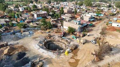
The execution of mega infrastructure development in India achieved a historic milestone on July 14, 2026, when engineering teams successfully completed the final structural breakthrough of the longest underground irrigation water tunnel of the nation. Located in the Katni district of Madhya Pradesh, the 11.952 kilometer long Sleemanabad Tunnel stands as the most critical engineering component of the massive 197 kilometer Bargi Right Bank Main Canal project. To mark the completion of the most challenging phase of the 17 year old initiative, Chief Minister Mohan Yadav physically inspected the subterranean site on July 17, 2026, detailing how the specialized channel will safely transport water from the massive Bargi reservoir beneath the ancient Vindhya mountain range directly into the parched Son river basin. Constructed at a depth ranging from 20 to 40 meters below the surface, the tunnel possesses an internal diameter of 10.14 meters and boasts a massive discharge carrying capacity of 227 cumecs, which represents the highest volume configuration among all canal systems operating across the state. The successful structural connection effectively brings to an end an intense engineering battle against nature, clearing the path for the official removal and dismantling of heavy tunnel boring machinery so that the natural flow of water can formally commence before the upcoming winter crop cycle.
The underlying brilliance of this massive water infrastructure project rests upon its sustainable hydraulic design, which relies entirely on natural gravity flow to channel water across the mountain barrier without consuming massive amounts of grid electricity for high power lift pumps. However, achieving this perfect slope through changing geological strata required workers to dig through extreme darkness and face dangerous underground realities for nearly two decades. Ever since physical construction operations officially commenced in 2008, the state run Narmada Valley Development Authority faced persistent technical roadblocks that completely halted initial project timelines. Excavation crews utilizing an imported American Robbins tunnel boring machine in 2011 managed to clear only 1.4 kilometers over a frustrating 4 year period due to encountering unexpectedly dense layers of marble, hard limestone, and abrasive dolomite formations. The structural stress grew severe as the heavy cutting disks broke repeatedly, forcing administrators to deploy a secondary German built HK tunnel boring machine from the opposite downstream end in 2016 to accelerate progress through simultaneous dual direction drilling. The human and technical resolve was put to the absolute test as teams had to continuously manage massive underground cavities, hazardous carbon dioxide gas leaks, and intense groundwater seepage that regularly flooded the shafts at a terrifying rate of 18,000 to 25,000 liters per minute.
While the final breakthrough is rightfully celebrated as a triumph of modern technology, a realistic evaluation of the execution path reveals the high price of administrative delays and early planning errors. The prolonged 17 year construction timeline caused the total project cost to explode from an initial estimate of 799 crore rupees to a staggering final expenditure of nearly 1,600 crore rupees, placing a heavy financial burden on the public treasury. This massive delay indicates that initial geological surveys failed to accurately predict the complex underground water pockets and shifting rock conditions of the Vindhya ridge. Furthermore, the choice to depend on a single cutting face during the first decade of construction unnecessarily prolonged the suffering of regional agricultural communities that were promised reliable irrigation links years ago. The technical choice to avoid an open cut excavation methodology was ultimately justified, as a traditional open canal would have required the disruptive removal of more than 40 million cubic meters of earth and caused severe damage to the national highways, active railway tracks, and dense rural settlements that sit directly above the safe underground passage. The state administration had to carry out sensitive local rehabilitation and distribute fair financial compensation packages to surrounding communities, showing that large scale public works must be handled with deep human empathy to maintain institutional trust.
The successful completion of this underground link is poised to completely revolutionize the rural economy of central India by providing permanent water security to a total command area of 1.85 lakh hectares across 6 historically drought prone districts. The expanded canal layout will deliver an assured supply of clean surface water to approximately 2.45 lakh hectares of agricultural land spread across 1,450 rural villages in Jabalpur, Katni, Satna, Maihar, Rewa, and Panna. Local agricultural maps indicate that the project will specifically irrigate 21,823 hectares in Katni, 54,227 hectares in Maihar, 1,04,970 hectares in Satna, 448 hectares in Panna, and 3,532 hectares in Rewa, while concurrently channeling water to secondary local department storage pools covering another 30,307 hectares. Beyond the immense economic benefits for local farmers who can now transition to high value cash crops, the engineering feat symbolically unites the Narmada and Son basins, two ancient river systems that local mythology long claimed were destined to flow in completely opposite directions. As regional engineering units shift their focus toward finishing the remaining downstream distribution networks over the next three seasons, this gravity driven water tunnel stands as an important historical example of how sustainable engineering design can successfully overcome harsh geographical barriers to serve human needs.