
Google Maps Changes Lake Ontario to Lake America for US Users Following Presidential Order
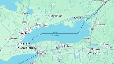
A diplomatic and cartographic controversy between the United States and Canada has crossed into the digital sphere after Google officially updated its mapping services to reflect a new national designation for a historic shared body of water. Users accessing Google Maps from within American borders now see the body of water labeled as Lake America rather than Lake Ontario. The tech company confirmed that the change was implemented to align its digital navigation software with official updates made by the United States Geographic Names Information System. The decision marks the latest escalation in a bitter cross-border feud that began with tariff disputes and has now expanded into geographic renaming policies.
The digital modification follows an executive order signed by President Donald Trump titled Honoring the American History of the Great Lakes and Renaming Lake Ontario as Lake America. The decree directed the United States Department of the Interior to officially reclassify the body of water, which sits between the state of New York and the Canadian province of Ontario. The White House justified the unilateral renaming by arguing that American taxpayers fund the majority of environmental protections, coast guard security, and icebreaking operations that keep the shipping channels open across the Great Lakes system.
Google clarified that its platform will display different labels depending on the physical location of the user. According to the company, individuals browsing Google Maps within the United States will see Lake America, while users accessing the service in Canada will continue to see Lake Ontario. For international users outside North America, the platform will display both designations, placing the new American term alongside the traditional name. The company noted that this localization strategy represents its standard policy for geographic entities that are officially recognized by different titles across separate national jurisdictions.
The move closely mirrors a similar development that occurred when Google Maps altered the label of the Gulf of Mexico to the Gulf of America for American audiences following an earlier executive decree. While Google quickly synchronized its mapping databases with federal naming standards, other navigation and software providers have taken divergent approaches. Major competing mapping services have either delayed implementing the change or announced that they will retain the original title, citing global cartographic consensus and historical continuity.
In Canada, political leaders and citizens reacted with frustration and mockery, firmly rejecting the notion that an executive order from Washington can erase centuries of shared geography. Canadian Prime Minister Mark Carney emphasized that the name Ontario originates from the Indigenous Wendat language word meaning large and beautiful water, pre-dating both the founding of the Canadian Confederation and the United States Declaration of Independence. Canadian officials stated that their national atlases, legal records, and maritime charts will permanently preserve the historic name.
Provincial leaders also took direct public action to push back against the renaming. Ontario Premier Doug Ford unveiled a prominent billboard along the Canadian shoreline declaring the body of water Lake Ontario now and forever. Provincial authorities also launched an immediate review of government websites after several public agencies discovered that automated map widgets pulling data from Google services had begun displaying the American designation to Canadian visitors.
The geographic dispute is taking place against the backdrop of an intense trade war between the two neighboring economies. High-level trade negotiations between Washington and Ottawa collapsed after reciprocal fifty percent tariffs were enacted on billions of dollars in cross-border commerce, severely straining supply chains in the automotive, agricultural, and energy sectors. Political observers note that the dispute over Lake Ontario reflects how economic tensions can rapidly spill over into cultural and symbolic conflicts.
For everyday users navigating digital maps, the split naming system highlights the growing fragmentation of digital information along national borders. As private technology platforms face legal and regulatory pressures to conform to domestic political mandates, digital maps increasingly reflect distinct national narratives rather than a single universal geography.