
Gujarat Heavy Rain Triggers Flood Red Alert In 13 Districts As 1500 Residents Evacuated In Surat
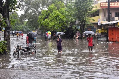
A massive downpour has disrupted daily life across central and south Gujarat, transforming busy city streets into flowing rivers and placing local administration on high emergency alert. On July 31, 2026, continuous heavy torrential downpours battered multiple urban centers and rural belts, forcing disaster management authorities to evacuate more than 1500 people from submerged low-lying settlements. Surat emerged as the worst impacted urban zone, with its Umarpada sub-district recording an astounding 247 mm of rainfall within just 8 hours. Water levels rose rapidly across 59 key city locations, flooding major arterial roads, commercial residential areas, and threatening residential compounds near overflowing natural drainage channels. In response to the worsening situation, the India Meteorological Department declared a red alert for 13 vulnerable districts, including Surat, Vadodara, Ahmedabad, Anand, Narmada, Bharuch, and Navsari.
The sudden intensity of the weather system left thousands of ordinary citizens struggling against knee-deep water logging, stalled traffic, and urban isolation. In places like Nadiad within Kheda district, 191 mm of rain fell in a short 8-hour window, while nearby Borsad recorded over 170 mm of downpour, causing floodwaters to inundate ground-floor homes and local shopfronts. To prevent loss of life, state rescue agencies acted swiftly by deploying 17 National Disaster Response Force teams, 33 State Disaster Response Force platoons, and 6 specialized Army columns to conduct boat rescues and distribution of essential relief packets. Educational institutions, colleges, and local anganwadi centers across affected districts were ordered to close down on July 31 and August 1, 2026, as a precautionary safety measure, while district authorities in Surat instructed local industrial factories to pause operations for 2 days to minimize public traffic on flooded roads.
The rapid breakdown of urban movement across major coastal and industrial hubs highlights a recurring challenge faced by fast-growing municipal centers during peak monsoon cycles. While heavy rain is an expected annual natural occurrence, the quick accumulation of floodwaters across dozens of city neighborhoods reveals persistent structural gaps in urban storm drainage capacity and natural water channel management. Rapid construction, paved surfaces, and clogged drainage networks frequently prevent heavy rainwater from draining out smoothly into major rivers, turning moderate flood risks into severe local emergencies. Emergency relocations and temporary industrial shutdowns successfully protect human lives in the short term, yet the frequent disruption to trade, transportation, and daily livelihoods points toward a pressing need for resilient infrastructure updates and proactive urban planning capable of handling unexpected localized cloudburst events.
Looking forward, the disaster management machinery remains on peak vigilance as 21 state reservoirs reach capacity thresholds across the state. State disaster relief commissioners and local administration officers continue late-night monitoring operations, coordinating directly with military personnel to manage overflow from rising river basins. For the thousands of displaced residents currently sheltered in temporary relief centers, the immediate relief effort provides safety, but true long-term relief depends on how effectively local civic bodies strengthen city drainage systems before the next intense weather cycle arrives.