
Nepal Tibet Flash Flood Leaves 750 Dead and 3044 Missing After Mountain Collapse
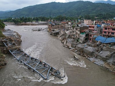
A massive wall of dark grey sludge, shattered timber, and giant boulders roared through the steep gorges connecting northern Nepal and Tibet with terrifying force. On 26 August 2026 at approximately 8:37 AM local time, an enormous frozen mountain slope broke apart near the high northern frontier. The falling mass of rock, ice, and frozen soil plunged more than 1200 meters into the valley floor below, generating shockwaves equal to a magnitude 5.2 seismic event. The extreme friction and kinetic force liquefied massive chunks of ice instantly, turning the riverbed into a fast-moving torrent of thick slurry. Within moments, the debris blocked narrow river canyons along the Lhende Khola and Bhote Koshi channels before bursting through, sending a ferocious flood surging down the entire Trishuli River basin.
The sudden disaster struck bustling market hubs, quiet farming villages, and ancient trade routes with zero warning. In a matter of minutes, the churning sludge tore through concrete hotels, international customs offices, heavy transport trucks, and suspension bridges across the Gyirong Port international border crossing. Local residents, shopkeepers, and travelers had only seconds to react to the deep roar of grinding stones. Many people survived only by climbing up rocky cliffs or holding on to the top branches of sturdy trees, watching in shock as family homes, vehicles, and entire streets dissolved into the dark water. The surge moved at speeds reaching 180 kilometers per hour, giving downstream settlements like Syabrubesi, Timure, and Betrawati Bazaar no chance to evacuate before flood levels jumped by 9 meters in under 30 minutes.
Emergency response teams from the Nepal Army, the Armed Police Force, and Chinese disaster personnel continue to search vast fields of deep mud. Official counts confirm 750 people dead and 3044 people missing across Nepal and Tibet. Among the unaccounted are 589 foreign nationals, including travelers and pilgrims from India, the United States, the United Kingdom, Australia, Canada, and Malaysia. The powerful current carried debris and victims more than 240 kilometers downstream into southern plains, where recovery operations are still underway. Key transport routes connecting Kathmandu with the northern border remain completely cut off in dozens of sections, while major hydroelectric plants along the river corridor suffered massive structural failure, causing long power blackouts across central Nepal.
The scale of the destruction highlights severe weaknesses in regional safety networks and infrastructure planning along steep mountain river valleys. Standard river monitoring gauges along the water system were smashed instantly because they were designed for slow seasonal rains rather than violent, sudden debris flows, preventing warning sirens from reaching downstream populations in time. While mountain landslides are natural occurrences, rising regional temperatures continue to weaken the deep frozen ground that acts like natural glue holding high mountain ridges together. Constructing heavy highways and multi-million dollar power projects directly inside narrow river paths without automated satellite radar systems creates continuous danger for nearby communities. Protecting human lives requires building settlements on higher ground, enforcing strict zoning laws, and setting up real-time sensor networks capable of detecting mountain movements the instant they happen.